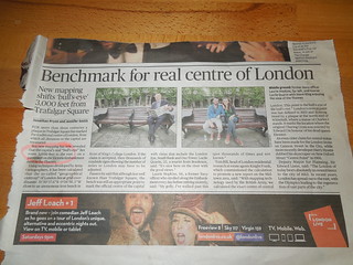
On the train home yesterday I picked up the Evening Standard and read this article on the 'new' geographical centre of London.
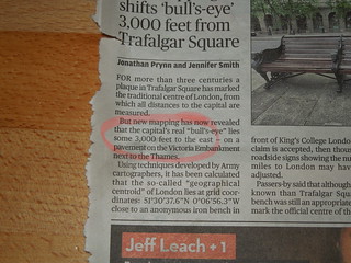
I have a great deal of sceptism with this article. Depending how you define the centre, it can move no doubt kms across the middle of London. It grates me that they say "techniques developed by Army cartographers". What does that pseudo official phrase mean especially as there is no more detail to back it up? And these techniques were then used by estate agents to define the centre (or, to quote, "the bullseye of the bullseye"). I know some estate surveyors are Chartered Surveyors, but with all due respect, they are not geomaticians.
And whilst I'm at it, the second phrase that annoys me is "grid coordinates: 51°30’37.6”N 0°06’56.3”W". No, those are not grid coordinates, those are geographic coordinates. OK, call me a pendant but there you go.
Anyway, there will be 101 different ways of computing the centre of anything depending on where you define the edge of London, what projection you base any measurements on, if you use relief etc. The first point is the key parameter - where on earth does London officially stop? When you get to a certain density of dwellings (residential and/or commerical property)? M25? Zones of the underground?
Mr Londonist in his 2010 blog found 3 different centres depending on various boundaries and a good dose of Blue Peter problem solving. Ace. And his recent update has a new suggestion which is 51° 30′ 1.806956″N 000°06′ 33.458418"W. This position definition looked pretty scientific too, perhaps based on a "technique developed by Army cartographers" (OK, yes, it is bugging me!). This point is over 1km away from the estate agent's suggestion. And the precision quoted is sub millimetric which is nonsense. Sub millimetric precision (not accuracy for sure which is claimed to be 40cm) is mumbo jumbo especially when talking of an estimated position. I could go on. I shall refrain.
But just as a little PS, I was most interested to note that the print version of this article talks of 3000 feet, whereas the online is metric.
Perhaps they see different audiences for paper compared with digital? As far as I'm concerned everything should be metric. And if my Mum complains that they are quoting rainful figures in inches ("why not use cms Ruth?" she commented) then it's a no brainer.