On 23 December I took myself off for a windy and wet walk around St Thomas, Exeter. I had an excellent leaflet I'd picked up from the local library and set off to explore. However, never being one to miss an opportunity, I also downloaded a list of the local benchmarks to enhance my exploration of the area.
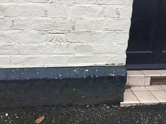
The first one was an easy find as I often see it - at the end of Cotfield Street (just off Water Lane).
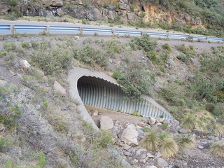
The second mark was on the railway bridge crossing Alphington Road just north of St Thomas railway station. I've looked for this dozens of times but this time I was armed with the Ordnance Survey listing and realised I was looking on the wrong corner.
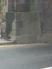
You can just see it in the centre of this picture: just slightly off centre to the top and right. And I now know why I hadn't chanced on this. It's on the side of the tunnel opposite to the pedestrian walkway. I had to take a shot from across the road or chance getting squished by local traffic.
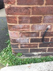
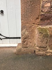
My third benchmark (and I hadn't even started the history trail yet) was on the school wall in Union Street.
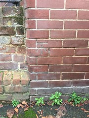
And, ta dah! Another one in the same road.
This is on 46 Union Street. I sometimes wonder if it's a bit creepy taking a photo of someone's front door but it's all in the name of geomatics so that's OK then.
I eventually started the trail and explored up and down Cowick Street. I saw the broad gauge railway sleepers leaning against the GWRSA, Great Western Railway's social club. Brunel's rails were re-laid to standard gauge in 1892. I discovered that there are 62 arches between St Thomas and Exeter St Davids stations. No luck finding the benchmark on the railway bridge over Cowick Street. I think it was removed during the public convenience installation.
I hadn't realised that the local Polish delicatessen, Maya, is the old County Prison for Debtors. And that the archway of the local garage, Cowick Street Motors, was the entrance to it.
I ambled up Cowick Street failing to find another listed benchmark. The Age Concern building used to be the local fire station. It's funny what you see when you look up above a modern shop sign to read the carved stonework above.
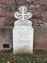
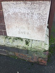
I walked into St Thomas church grounds and found the memorial to Grace Darling. Hardly a local event but it must have had a connection with someone in St Thomas.
And, as expected, there was a nice old benchmark on the church (nail in this one).
I walked up as far west as the St Thomas National School which, in its day, housed 300 children taught by just 3(!) teachers. Then through St Thomas Pleasure Ground back into Buller Road. This building used to be the pumping station for the St Thomas Water Works.
At the end of Buller Road, just before you turn into Okehampton Road, there is a mark scratched into the wall marking the height level of the flooding on 26 October 1960.
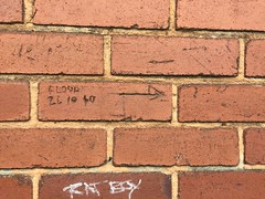
You can see how high it is. 'Ruth-nose-level' is the official, chartered survey, measured height.
The trail wound past the Emmanuel Parish Church, the River Exe (path closed sadly) ending at the eastern edge of Cowick Street. In the pavement is a brass ram's head commemorating a runaway tram accident in 1917. What a wonderfully interesting walk.
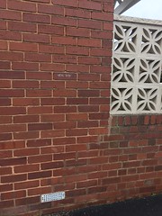
Later that evening, never one to be off duty, I found another benchmark in a local cut-through.
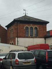
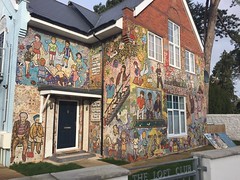
And the next day discovered a beautifully mosaicked building in Tin Lane.
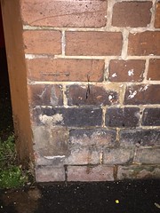
And then I discovered my seventh benchmark for this blog, on the hall in Cowick Street.
Sadly I couldn't find my last quest, the one at 21 Cowick Road. Again, there is only so long I think I can linger outside someone's door before looking just a little too weird.
The first one was an easy find as I often see it - at the end of Cotfield Street (just off Water Lane).
The second mark was on the railway bridge crossing Alphington Road just north of St Thomas railway station. I've looked for this dozens of times but this time I was armed with the Ordnance Survey listing and realised I was looking on the wrong corner.
You can just see it in the centre of this picture: just slightly off centre to the top and right. And I now know why I hadn't chanced on this. It's on the side of the tunnel opposite to the pedestrian walkway. I had to take a shot from across the road or chance getting squished by local traffic.
My third benchmark (and I hadn't even started the history trail yet) was on the school wall in Union Street.
And, ta dah! Another one in the same road.
This is on 46 Union Street. I sometimes wonder if it's a bit creepy taking a photo of someone's front door but it's all in the name of geomatics so that's OK then.
I eventually started the trail and explored up and down Cowick Street. I saw the broad gauge railway sleepers leaning against the GWRSA, Great Western Railway's social club. Brunel's rails were re-laid to standard gauge in 1892. I discovered that there are 62 arches between St Thomas and Exeter St Davids stations. No luck finding the benchmark on the railway bridge over Cowick Street. I think it was removed during the public convenience installation.
I hadn't realised that the local Polish delicatessen, Maya, is the old County Prison for Debtors. And that the archway of the local garage, Cowick Street Motors, was the entrance to it.
I ambled up Cowick Street failing to find another listed benchmark. The Age Concern building used to be the local fire station. It's funny what you see when you look up above a modern shop sign to read the carved stonework above.
I walked into St Thomas church grounds and found the memorial to Grace Darling. Hardly a local event but it must have had a connection with someone in St Thomas.
And, as expected, there was a nice old benchmark on the church (nail in this one).
I walked up as far west as the St Thomas National School which, in its day, housed 300 children taught by just 3(!) teachers. Then through St Thomas Pleasure Ground back into Buller Road. This building used to be the pumping station for the St Thomas Water Works.
At the end of Buller Road, just before you turn into Okehampton Road, there is a mark scratched into the wall marking the height level of the flooding on 26 October 1960.
You can see how high it is. 'Ruth-nose-level' is the official, chartered survey, measured height.
The trail wound past the Emmanuel Parish Church, the River Exe (path closed sadly) ending at the eastern edge of Cowick Street. In the pavement is a brass ram's head commemorating a runaway tram accident in 1917. What a wonderfully interesting walk.
Later that evening, never one to be off duty, I found another benchmark in a local cut-through.
And the next day discovered a beautifully mosaicked building in Tin Lane.
And then I discovered my seventh benchmark for this blog, on the hall in Cowick Street.
Sadly I couldn't find my last quest, the one at 21 Cowick Road. Again, there is only so long I think I can linger outside someone's door before looking just a little too weird.