Thursday 31 May 2007

Mashup of Mashups

Have just stumbled across Google Mapplets described as the mashup of mashups (reviews here and here). Also see an article from the RICS on mashups. They look quite good fun. The mapplets directory has add on layers which have already been developed. I quite like the distance measurement tool but haven't quite seen the use of drilling a hole through the earth?


I'm sure there is a point.

Sunday 27 May 2007

Tidying Up

Decided to reclaim a corner of the room today where I dump my collection of geo magazines. So today I scanned through and recycled a pile of Geomatics World, GIS Professional, Hydro International, Soundings, FIG2006 conference proceedings, Maplines and the Ranger.


Read through subjects ranging from imagery in Hamburg, surveying in Antartica, the new OSNet in the UK, geomatics education in Latvia, FIG in Hong Kong and numerous other fascinating snippets which I shall no doubt soon forget.

Exciting afternoon eh?!

Tuesday 22 May 2007

Trig Pillar Fan Club

OK, I have to confess that I quite like trig pillars. It's a hark back to my past when every holiday snap of me as a kid involved me perched on a trig pillar!

Today I parked at Budleigh Salterton

and sauntered west along the South West Coast Path to West Down Beacon trig pillar.

Perhaps I should log it on this geeky site I've just found? Where TP6804 is. Actually the title of the link says "This site is designed for those people who are unable to walk past a trigpoint without bagging it." Ahem...

Saturday 19 May 2007

Orienteering for Life

Was browsing one of the magazines my girls bring home from school earlier and came across an orienteering website for Devon which has just started. What a fabulous idea! I am all for kids (and adults) charging around using maps to have fun. And there's hope for me when I retire too, as they do courses for over 75 year olds.

My daughter is off to secondary school soon and I know I'll wade in on the humanities department there and offer to talk about surveying, imagery, maps and all things geospatial. I will make use of geomatics.org too - a great site (although it doesn't seem to be talking to me tonight...)

Friday 18 May 2007

Bomb Blast in Hyderabad

Exactly where I was last month...

* my blog
* the detail
*the photos

But for the Grace of God we go...

Thursday 17 May 2007

Galileo, GPS and the New Look Multimap

It's not looking great for Galileo. However, there must be a way to make this work. This cannot turn out to be an EC white elephant. We need this. Just got to find a billion Euros. Now, let me just get my credit card...

GPS is a funny beast. Type GPS into 'google' and you find out everything you ever wanted to know about your local doctor (if you don't get it, don't worry). GPS, digital mapping and people - now there's the real danger. Check out this lady. Or these furious kids?

Not much else to report. Presume the lone walrus is happy being monitored.

Oh, what about the new look multimap? I don't like the zoom feature but perhaps I should be more patient. I need to play with it more.

Tuesday 15 May 2007

Can I Have My Tag Back Please?

I blogged a couple of weeks ago about GPS being used to tag walruses around Greenland.

GPS is wonderful. If the tags stay on that is...

Monday 14 May 2007

Monaco Update

Had a good week in Monaco. Smooth trip, even time for a 5 minute sight-see enroute from Nice Airport.

Conference was in full swing when I arrived. Met up with all those I wanted to plus got to meet a whole new bunch of contacts. Enjoyed the evening reception on HMS ECHO Tuesday evening.

The IHO meetings were very akin to FIG general assembly ones. Best not comment more!

Arrived back Friday afternoon but not very well. Not because of Monaco I hasten to add. Taking some time off work. Now this means I'm either going to go terribly quiet on this blog as I'm not 'doing anything' or I'll be posting every day as I'll be bored and surfing geo-geeky things on the web. We'll see.

Hope (probably in vain) I can make it up to London next week for an RICS meeting and evening lecture on international boundaries but I'll have to see.

Monday 7 May 2007

Off to Monaco we go

Fly to Monaco tomorrow for a few days at the IHO. It's the 17th international hydrographic conference and will be crawling with delegates the world over. I'm providing technical support to my work colleagues out there which basically means I get to have fun whilst they sit in the numerous meetings. OK, when I mean 'fun' I mean talking techie all day long. I'm looking forward to catching up with Steve Shipman from the IHB, Andrew Leyzack, Canadian Hydrographic Service and FIG (oooh, there's a picture of me on that latest link...), Rod Nairn, Australian Hydrographic Service, people from Maritime Coastguard agency, staff from NGA, other US guys I know, some of our contractors and, of course, oodles of companies. I've just downloaded the exhibition brochure - lovely stuff. Really looking forward to being in an environment where I excel.

Staying in the Mirabeau and I've just spotted the pool on the website. Some hope if I get anywhere near it! It's such a golden opportunity to catch up with some many people I'll be chatting non-stop. No change there then.

Thursday 3 May 2007

Cultural Taunton

Not quite sure if I've ever put those two words together before but perhaps I'm just being unfair.

Was skimming my copy of RICS Business tonight. There's rarely much to write home about in there for me but an article on regeneration in the South West caught my eye, particularly the section about Taunton. So 'Project Taunton' is alive and kicking. Can't wait to see the cultural quarter! Mind you, from my one and only paddle on the Tone they need to clean that up first. Phewy.

Tuesday 1 May 2007

A Great Circle for Dad

I do love my Dad (ahem, I always love him) when he sends me 'interesting' questions. Tonight's was

"When we fly from London Heathrow to Vancouver assuming we use the great circle, how far north does it get?"

Ah, now calculating a great circle is easy. I used this for a rough and ready answer, complete with pretty picture. It's approx 4111 nautical miles if you're interested.


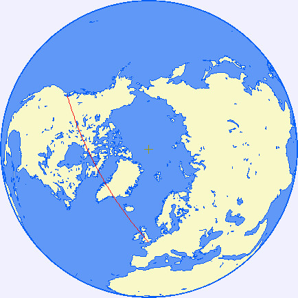
Calculating the most northerly point was a bit more trial and error. To save myself brain ache I simply put in latitude and longitude from the previous programme (LHR = 51°28'39"N 00°27'41"W, YVR= 49°11'38"N 123°11'04"W into this programme and asked for a waypoint 'half' way round, ie at 061°W. OK, not terribly scientific but the approx answer is 68° 40' North.

I'm sure there are far more clever people out there who will do this standing on my head but, how does that look Dad? It's a bit more accurate than my husband's suggestion of holding a piece of string between London and Vancouver over a globe. Mind you, probably similar result!