Wednesday, 31 March 2010
OS Where Art Thou?
The Ordnance Survey's new business model rolls out on 01 Apr 10. It was debated in the House of Lords on 24 March, 1510 onwards, and we've been eagerly awaiting the new look OS since then. Not long now. Only 2 hours to go... Nothing on the OS website. Have I missed something?
Tuesday, 23 March 2010
Oceanology International 2010
A somewhat belated post on my fun geeky conference the other week. I attended OI10 earlier in the month primarily to help out on the RICS stand. As it turned out I'd just moved into a Defence related post at work so spent quite a bit of time on a steep learning curve learning all about mine hunting, oceanographic datasets, environmental data providers and ROVs.
I spent a happy 90 mins on HMS CATTISTOCK learning about mine countermeasures, how the SeaFox works and, of course, the vital cup of coffee with Ops!

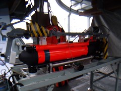
On the non-MOD front spent an hour or so on Gardline's vessel, MV Confidante chatting about mulitbeam (I now understand what a dual multibeam system is) and other hydro survey things which I should know but embarrassingly don't.
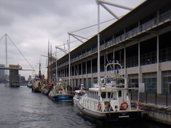
In between the RICS stand, the vessels, the oceanographic lessons on XBTs, CTDs and ADCPs it was lovely to bump into many old friends. It took forever to walk from one end of the exhibition to the other as there were so many familiar faces to stop and chat to.
And only 23.5 months until the next one...
I spent a happy 90 mins on HMS CATTISTOCK learning about mine countermeasures, how the SeaFox works and, of course, the vital cup of coffee with Ops!
On the non-MOD front spent an hour or so on Gardline's vessel, MV Confidante chatting about mulitbeam (I now understand what a dual multibeam system is) and other hydro survey things which I should know but embarrassingly don't.
In between the RICS stand, the vessels, the oceanographic lessons on XBTs, CTDs and ADCPs it was lovely to bump into many old friends. It took forever to walk from one end of the exhibition to the other as there were so many familiar faces to stop and chat to.
And only 23.5 months until the next one...
Wednesday, 17 March 2010
Dorchester Trig and Survey Marks
I'm a bit behind myself here. Had a fab time at OI10 but haven't yet received the photos to do justice to a decent blog. Therefore I will fast forward to my last weekend which saw me in Dorchester with my Mum.
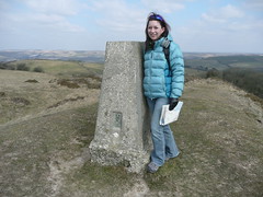
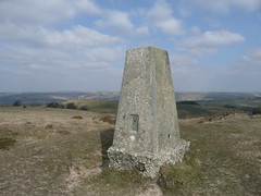
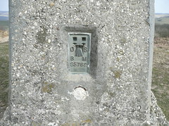
My Mum is pretty tolerant of her family and I blame a lot of my geo passion on her and my Dad, but I still don't think she can quite get over my trig pillar passion. She graciously let me visit one on a stroll around Abbotsbury, Dorset. TP0768
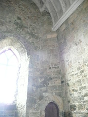
It got worse. After lunch in Abbotsbury we decided to visit St Catherine's Chapel.

We were doing well until we walked inside and I saw the survey marks. I presume it's an English Heritage laser scanning conservation project (click on photo to see marks).
Great excitement from a Ruth. Major rolling of eyes from my mother!
My Mum is pretty tolerant of her family and I blame a lot of my geo passion on her and my Dad, but I still don't think she can quite get over my trig pillar passion. She graciously let me visit one on a stroll around Abbotsbury, Dorset. TP0768
It got worse. After lunch in Abbotsbury we decided to visit St Catherine's Chapel.
We were doing well until we walked inside and I saw the survey marks. I presume it's an English Heritage laser scanning conservation project (click on photo to see marks).
Great excitement from a Ruth. Major rolling of eyes from my mother!
Friday, 5 March 2010
The Earth Moved
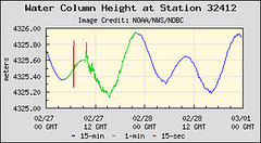
A rather tardy post on the Chile Earthquake. You can see evidence of the quake in the buoy measurements off the coast of Chile. The National Data Buoy Center shows water depth every 15 seconds and at 0645 on 27 Feb there are water variations of +/- 0.5m. This in over 4000m depth on a buoy which has usual 15 variation of 0.01m. The red lines show major movement.
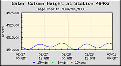
Further north, just over 17 hours later, another buoy measured the effects of the earthquake.
These two places are approx 6000km apart which means that the waves moved at around 350km an hour. You don't get much warning when one of these takes off do you?
The NOAA Pacific Tsunami Warning system was in full swing. At 0645 the first messages started coming through
AN EARTHQUAKE HAS OCCURRED WITH THESE PRELIMINARY PARAMETERS
ORIGIN TIME - 0634Z 27 FEB 2010
COORDINATES - 36.1 SOUTH 72.6 WEST
DEPTH - 55 KM
LOCATION - NEAR COAST OF CENTRAL CHILE
MAGNITUDE - 8.5
EVALUATION
IT IS NOT KNOWN THAT A TSUNAMI WAS GENERATED. THIS WARNING IS
BASED ONLY ON THE EARTHQUAKE EVALUATION. AN EARTHQUAKE OF THIS
SIZE HAS THE POTENTIAL TO GENERATE A DESTRUCTIVE TSUNAMI THAT CAN
STRIKE COASTLINES NEAR THE EPICENTER WITHIN MINUTES AND MORE
DISTANT COASTLINES WITHIN HOURS. AUTHORITIES SHOULD TAKE
APPROPRIATE ACTION IN RESPONSE TO THIS POSSIBILITY. THIS CENTER
WILL MONITOR SEA LEVEL DATA FROM GAUGES NEAR THE EARTHQUAKE TO
DETERMINE IF A TSUNAMI WAS GENERATED AND ESTIMATE THE SEVERITY OF
THE THREAT.
and they escalated from there to
A TSUNAMI WARNING IS IN EFFECT FOR
CHILE / PERU / ECUADOR / COLOMBIA / ANTARCTICA / PANAMA /
COSTA RICA / NICARAGUA / PITCAIRN / HONDURAS / EL SALVADOR /
GUATEMALA / FR. POLYNESIA / MEXICO / COOK ISLANDS / KIRIBATI /
KERMADEC IS / NIUE / NEW ZEALAND / TONGA / AMERICAN SAMOA /
SAMOA / JARVIS IS. / WALLIS-FUTUNA / TOKELAU / FIJI /
AUSTRALIA / HAWAII / PALMYRA IS. / TUVALU / VANUATU /
HOWLAND-BAKER / NEW CALEDONIA / JOHNSTON IS. / SOLOMON IS. /
NAURU / MARSHALL IS. / MIDWAY IS. / KOSRAE / PAPUA NEW GUINEA /
POHNPEI / WAKE IS. / CHUUK / RUSSIA / MARCUS IS. / INDONESIA /
N. MARIANAS / GUAM / YAP / BELAU / JAPAN / PHILIPPINES /
CHINESE TAIPEI
and included evidence from the buoys which were obviousy being closely monitored.
MEASUREMENTS OR REPORTS OF TSUNAMI WAVE ACTIVITY
GAUGE LOCATION LAT LON TIME AMPL PER
------------------- ----- ------ ----- --------------- -----
IQUIQUE CL 20.2S 70.1W 0906Z 0.27M / 0.9FT 72MIN
ANTOFAGASTA CL 23.2S 70.4W 0941Z 0.49M / 1.6FT 52MIN
ARICA CL 18.5S 70.3W 1007Z 0.94M / 3.1FT 44MIN
DART LIMA 32412 18.0S 86.4W 0941Z 0.24M / 0.8FT 36MIN
CALDERA CL 27.1S 70.8W 0843Z 0.45M / 1.5FT 20MIN
TALCAHUANO CL 36.7S 73.4W 0653Z 2.34M / 7.7FT 88MIN
COQUIMBO CL 30.0S 71.3W 0852Z 1.32M / 4.3FT 30MIN
CORRAL CL 39.9S 73.4W 0739Z 0.90M / 2.9FT 16MIN
SAN FELIX CL 26.3S 80.1W 0815Z 0.53M / 1.7FT 08MIN
VALPARAISO CL 33.0S 71.6W 0708Z 1.29M / 4.2FT 20MIN
The sad reality is that the earth moves. However with these monitoring networks you at least know they kick in very quickly and give everyone as much notice as possible to be on alert. That's the best you can ask for at times.
Subscribe to:
Posts (Atom)