Tuesday 28 December 2010

I Blame Glyn

I met Glyn Hunt a year or so ago (and he's the only person I know to have their own website - not sure what to make of that). It didn't take me long to realise he's as obsessed about benchmarks as I am trig pillars. I tried to ignore the pull. However I have just spent the week in Keswick with the family and realised quite soon on that the trig pillars were too high for us to reach cry. Sad but sensible when it's below freezing, ice/snow on top and the girls only had enough clothes to keep them warm at the foot of the hills, not 900m above MSL. So what to do except to cut my losses and start hunting for benchmarks? I didn't get too far as (a) the family only allow me out for brief periods lol and (b) we had no internet connection so I couldn't pre-arm myself with grid references to locate them.

So in the 30 mins I had last week (!) I/we found two.

Keswick Moot Hall and Keswick Post Office.


The beginning of the obsession starts.

Thursday 16 December 2010

Alvin - Space Shuttle of the Oceans

Wow, wouldn't this be a trip and a half? Good luck on the new model Alvin.

Saturday 11 December 2010

A Memorable Meeting

We had the RICS Geomatics Professional Group meeting at the RICS HQ, 12 Great George Street, on Thurs. It was Stuart Edward's first full meeting as Chair and our international reps were there. We knew, due to the vote on university fees, that there would be protests in Parliament Square, but no idea of the scale.

At 1350 a whole raft of students arrived from the Whitehall area. Actually I'd realised they were at Trafalgar Square 30 mins earlier as I could see the helicopters buzzing over that area from our 5th floor meeting room.

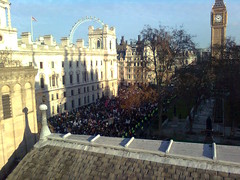
We went out on to the terrace to watch proceedings. It was increasingly confusing with demonstrators breaking through baracades and police lines moving. The students broke into the grass area of Paliament Square and pretty soon there were fires blazing (incl a bench) and someone had erected a gazebo - which certainly shows some planning ahead.

Poor Stuart had a job on his hands to keep us focused on the business of the day when events outside were far more interesting.

At 1500 we were told the police wanted us out in 20 mins. They were struggling to keep Paliament Square closed and, for our safety, wanted us out of the building. The RICS building is across the road from Treasury. We evacuated in 10 mins and then spent 30 mins walking to our hotel just the other side of Westminster Bridge. Of course we couldn't take a direct route so walked up Marsham Street (giving a wide berth to the Tory HQ in Millbank), across Lambeth Bridge and along the South Bank. We reconvined our meeting in a spare hotel meeting room - which was kind of them. This gave Peter Dare and I had an opportunity for impromptu chair race which I won (ha!).
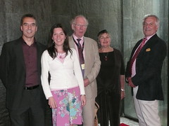
Martin Pratt, from IBRU, was due to give the evening lecture and receive the Michael Barrett award which, obviously, had to be abandoned. I was really looking forward to it but hey ho. He'd travelled down to London for no more than a meal with us lot before returning the next morning. I was delighted to sit next to him and have a good chinwag about datums in the Gulf ever over dinner, like you do. rolleyes

Around 2230 our hotel was surrounded by police vans and the entrance closed eek. We were also hearing rumours of tube stations being closed etc. I now realise that there was a group of protestors kettled on Westminster Bridge. We stood there in the bar, glasses in hand, and watched the proceedings. A very bizarre end to the day.

Let's hope, for Stuart's sake, next time round it's all a lot more normal.

Sunday 5 December 2010

Monday 29 November 2010

Stellar Christmas

I was up in London on Sat exploring the lights with my daughter. Trafalgar Square was boring - I suspect they don't put their lights up until 01 Dec - Covent Garden better, Regents Street good but Carnaby Street was by far the best. Check out these stellar Christmas lights!


Wednesday 24 November 2010

And Now for Something Completely Different

If I ever talk about a military group in my blogs it's the Navy. However it's the Army's turn today. Mind you, it's hardly geo, more just a bit of interest to any army followers I have out there. OK. One. Ken - this blog is for you. wink

I was invited to join some 'in service' testing on Salisbury Plain today. I know the guy who works on weapons at Abbeywood and since I had no pressing meetings today I was able to take the day off to spend freezing my toes watching the Army (and a couple of Marines I spotted) practising.

We were on a range testing the Javelin and light/heavy machine gun fire. There was a bit of action with Warriors, smoke grenades and small explosions and then machine gun fire (with tracers) onto distant targets. Elsewhere on the Plain we could hear big gun fire going off and clouds of smoke rising on the horizon.


They set up a Javelin so that we spectactors could peer through the view finder.

The great excitement (if you can call it that) was when one of the Javelins misfired. The project engineers there had never seen it happen. Post failure all one could hear were sighs of "oh dear, oh dear, oh dear". Nothing is perfect but reassuringly when it misfired it cartwheeled and lay on the ground. No big 'boom'. No injuries.

I chatted to some of the army guys there but they are in a completely different world to the one I inhabit. Standard scathing of the dark blue forces. "All they do is swan around on ships sunning themselves". "Civil Servants just move paper around all day long" (sounds easy - I should try that some time). I didn't get onto the RAF but I was getting the gist. One poor guy was missing his para mates who were out in Africa and he was stuck on Salisbury Plain running training and exercises. I can imagine that's not what he joined up for. Another one offered me an egg-butty. When I declined he up-ed his offer "free hug with every egg-butty!". Now, there's an offer you don't get every day. cool

Saturday 6 November 2010

Team Surv and Open Sea Map

TeamSurv is 2 year project, which started around the beginning of this year. It's an EU sponsored CoSuDEC project (Coastal Surveying of Depths with EGNOS to enhance charts) investigating the use of crowd sourcing to log position and depth data from seagoing vessels. It then processes the data to enhance the quality of nautical charts, and data sets for GIS systems as used by coastal engineers, for example.

As you can see form Tim Thornton's response the data is not yet suitable for navigational charting, although it is an aspiration.

It reminds me of Open Sea Map which has similar aspirations. Open Sea Map is about collecting the whole gambit of nautical information - although interestingly it can't yet take depth info as it's not 3D. rolleyes Their market is focused on the leisure market adding additioinal local knowledge. Team Surv is more about collecting raw data to improve knowledge of the sea bed. Similar but different. Perhaps they should combine forces?

Sunday 31 October 2010

Navigating in the Arctic - Challenges

An interesting article on the challenges of positioning and navigating in high latitudes. I touched on this earlier this month and I suspect this will be an increasingly discussed subject.

Monday 25 October 2010

Sightseeing Benchmarks (or rather, BMs rock)

A story of benchmark love...

A surveying friend of mine is a tad obsessed about benchmarks (nothing abnormal about that). His cousin recently made the mistake of asking him what a benchmark was. He explained and pointed out a few at which stage she was hooked. Good woman.

Anyway, she works for a homeless charity. She returned to work enthused about BMs and soon her team were out at lunchtime looking for them. They even searched the online BM database to find more.


When their CE heard about it he instantly thought it would be a great alternative exercise for them and the people their charity helps. It gets everyone up and out walking, chatting, seeing the sights - well, if you count benchmarks as sights.

Who'd ever have thought the humble benchmark would be helping the homeless?

Sunday 17 October 2010

A Satellite Waltz

This looks interesting. A satellite dance for a DEM.

Thursday 14 October 2010

CPS 98 - Conscientious Objectors Survey America

Enjoyed reading this article about CPS 98 the "odd geodetic survey crew". I'd never thought what a nation would 'do' with conscientous objectors. There were 43,000 in the US and, from what I read, the ones who turned to surveying had a good time. Less so those who 'volunteered' to be human guinea pigs in medical experiments. No thanks. Give me a tent and a theodolite everytime.

Monday 11 October 2010

The History of the World in 100 Objects

This is an interesting series but I haven't been paying much attention to it. Until now when these latest two episodes were bought to my attention.

Last week we had a North America buckskin map. Transcript is here.

But this week is better, Darwin's chronometer (or, rather, one of the 22 chronometers on HMS BEAGLE). Full transcript is here. I read Longitude with much interest some years ago so this was a good 15 mins of radio listening. cool

A bit more snooping around has unearthed a Hebrew Astrolabe and a Mexican codex map. It's funny but I didn't find the British Museum at all inspiring when I was there last month - it just goes to show that the story behind the object can make all the difference.

Friday 8 October 2010

Oceanography Library Goes Digital

OK, a bit behind the news here but worth reporting albeit a few months late. Reported in Marine Data news in June.

"Approximately 100,000 volumes from the Scripps Institution of Oceanography Library, the world’s largest oceanography library, have been digitised and are being made publically accessible as part of a partnership between Google, the University of California and the UC San Diego Libraries."

And here we go - the library itself. Wow, you could virtually lose yourself in here...

Thursday 7 October 2010

Navigating Up North

This article on the Northwest Passage caught my eye in the Guardian the other week. Quite a balanced report. The accuracy of the charting in Canadian waters is coming under increasing scrutiny as more ships sail in the Arctic. It's a national dilema. Hydrographic surveying is very expensive and governments cannot afford to survey every square mile of their territory. They have to focus their efforts on those areas which are most used. Advice from the Canadian Coastguard is here.

Does 24 cruise ships in 7 months count as heavy use? No. But if one of those runs aground and has a fuel spill which causes $millions to clean up who pays? The government (in the first instance). Risk versus cost. The universal dilemma. Should those ships who use these areas pay for the charting? A nice idea but cost prohibitive I suspect.

The Russians are using imagery to advise on clear routes through the ice. Certainly no replacement for navigational charts (of whatever source data vintage) but anything helps. I suspect forward looking radar are the best bet but even that didn't work for HMS ENDURANCE the other year.

Tuesday 28 September 2010

Sunday 26 September 2010

Trig Pillar Hugging

I handed over Chair of the RICS Geomatics Professional Group on Monday 20 Sept and one of my vows was to spend more time with trig pillars (was I meant to say my family?!).

Anyway, after a glorious day out at Saltram with my girls today espied a little something on a hill...

TP2812 , Dorsmouth Rock, a wee hop and a skip across a field gives one some gorgeous Plymouth views.

Meridian Hunting

I spent last week in London on leave. A bit of RICS, a good dose of catching up with relatives and lots and lots of exploring London.

I liked the nautical theme of the 4th plinth in Trafalgar Square, currently Nelson's ship in a bottle.

Spotted some locals - although they weren't using their theodolite, just standing around presumably waiting for their boss (far LHS of photo) to finish his phonecall.

Bumped in the Land Registry HQ

and kept an eye out for benchmarks without seeing any. Honestly, I really am useless at spotting them! rolleyes

Spent a gorgeously sunny afternoon in Greenwich sitting by the Thames watching the world go by. Popped up to the Observatory but no photos as I'd temporarily lost my camera (don't ask).

On Thursday my aunt and I visited Waltham Abbey for the sole intention of finding the meridian. I hadn't realised how close their house was to the meridian and spent a lot of my time fretting if I was east or west of Greenwich!

The most beautiful meridian line I've ever met.

And the Meridan gate (with aunt).

Happy days.

Wednesday 15 September 2010

Do you think in directions?

I hopped in a taxi today and asked the driver to take me to the north side of the railway station. He looked flumouxed. "Is that the side with the ticket machine?" he asked. I confirmed it was and then asked him what he calls that side of the station, "ah, the up line". I think in maps and whenever I'm travelling anywhere new I feel quite unsettled until I can see a map and place my new-found world in its correct geospatial position. I like to know which way north is. It's a big scary world out there but as long as I know which way is up I'm happy.

Friday 3 September 2010

National Trust Gems

Whislt visiting a National Trust property, the Vyne, with my family on Sunday I espyed some geo artefacts.

This map is a 3x enlargement of Simon's engraving of the great seal of the Commonwealth ordered to be made in 1651. On this side seen here it represents, in minature, a map of England (sic) and Ireland, in which the Vyne was named out of compliment to Chaloner Chute who was afterwards Speaker of the House of Commons.

There was another map from 1695, possibly Morden's, but it doesn't look like the Morden's I can find on the internet. Unfortunately the photo didn't come out well as I wasn't allowed to use flash.

In the 'stone room' I came across this lovely piece.

It was crafted by Francis Berry and was obviously used to measure the Vyne estate. I've googled Francis Berry and can't unearth any more about him - perhaps a local Hampshire surveyor?

Monday 23 August 2010

The Day the Earth Stood Still

A very interesting concept - what would happen if the earth stood still for a day? Well you get this - dry equatorial regions (including the Atlantic and Pacific oceans) but soggy northern and southern hemispheres of the world. Fascinating that they've worked out that the sea levels would be 1.4km difference.

Tuesday 17 August 2010

Charting the Seas in the UK

An interesting report from the UK Marine Monitoring and Assessment community - Charting Progress 2. The overview is worth a quick read esp if, like me, you're just trying to get the essence. The maps in this overview, also at this link.

Lots in here for my oceanographers at work to absorb.

Friday 13 August 2010

Hydrography in the Thames

Port of London Authority on TV. Check out John Dillon-Leech (he's the Irish one) and colleague explain what they've found here.

Wednesday 11 August 2010

Black Sea River

A very interesting story here about a recent discovery of a river under the Black Sea, with 10 times the flow of Europe's largest river the Rhine. Quite incredible.

Saturday 7 August 2010

Une Carte de Paris

Currently on holiday in France which explains my blogging absence (or I think it does). What with run up to holidays, getting ahead with work, packing and other end-of-term etc activities the blogging took a back seat.

Anyway, the other day we were up the Eiffel Tower. I haven't been up it for a few years and very much liked a small feature on the first floor with astro turf, fountains (fantastically good fun in the wind) and the map of the area about the tower.

One of my holiday books, which I've just started, is Map Addict (what a great website wink). I'm only a few chapters in but slightly kicking myself that I haven't yet tracked down the Paris Meridian. It took nearly a month in 1884 to reach the decision that Greenwich would host the prime meridian rather than Paris. The Paris meridian goes through the Observatoire de Paris and, from what I can work out from their website, you can only view it on a 120Euro pre-booked visit. Am I missing something? If so then (a) I'll have to start saving now and (b) I'll have to dramatically improve my French to get value for money from my spend.

Tuesday 6 July 2010

M27 - East - West - East - East - West

Spent a lot of the day on the M27 today. Drove to Whale Island, Portsmouth, for a meeting at NCHQ (Naval Command Head Quarters) then to Southampton Docks to visit Aurora. A massive ship, although not P&O's largest. She can take 2000 guests with a crew of 800. Spent our hour with the navigation team looking at how they use their ECDIS, plan their routes, update their charts etc.

After this, back on the M27 to Fareham to visit HMS COLLINGWOOD and their navigation training team. Had 15 mins in their state-of-the-art simulator which was great and very realistic. Somewhat quease-enducing straight after lunch. redface. We sailed out of Pearl Harbour complete with 3D google earth graphics, submarines, fires, storms etc. A useful discussion with their WECDIS trainer ensued after this.

Back on the M27 to Portsmouth again, to the Dockyard to visit HMS IRON DUKE, a T23 Frigate. Spent quite a while in the Ops Room until I got dragged out to join every one else on the bridge.

A fascinating whistle-stop tour of various marine establishments in Portsmouth/S'oton finding out how they navigation and use electronic charting. Lots of customer input. Good stuff. cool

Thursday 24 June 2010

Close Range Newcastle

I was up in Newcastle-upon-Tyne on Monday for a Geomatics Professional Group RICS Board. My last one as Chair which was quite bizarre. I've been Chair for over 2 and a half years which is certainly far longer than the standard 18 months recommended by the RICS. I hand over to Stuart Edwards, Newcastle University, in Sept, at which point I retreat into obscurity.

Having studied at Newcastle University for my degree I have a lot of affection for this place. The arches, in particular, are well known and this is where exam results were posted. Well, not quite for Land Surveying (as it was then) - ours were still posted in the Old Brewery Building; honestly, where else would you put surveyors?

We had a busy meeting but I had time between that and the next event to take the standard stroll down memory lane from the University to Osborne Road, Jesmond. I think about 3 of my blog readers will understand this statement.

In the evening we attended the reception for the ISPRS Commission V Close Range Symposium evening reception at the Civic Centre. The Civic Centre has a bit of a memory jogger for me as I did my finals in this place so it was weird to revisit it 20 years later. Golly, that makes me sound so old. Anyway, met up with lots of heavyweights of photogrammetry/remote sensing including Ian Dowman, who has recently retired from UCL.

Sunday 20 June 2010

Happy World Hydrography Day 2010

Tomorrow we celebrate World Hydrography Day. This date has been chosen by the IHO, International Hydrographic Organization, to celebrate the anniversary of its creation. It is a day to recognise the contribution that hydrographic surveying makes to the maritime community.

This year's theme is Hydrographic Services - the essential element for maritime trade. Which, indeed, they are. More on the theme can be found at the Hydrographic Society news page or at Hydro International. It is good to see that this is being celebrated so widely.

Nigeria, India, the UKHO (in Singapore), Australia, Canada and the UK Hydrographic Society (in London) and no doubt many others are celebrating this day in one way or another.

I am up in Newcastle-upon-Tyne tomorrow for an RICS meeting and will be bumping into the ISPRS Commission V groupies in the evening. Not sure how close range you need to get with hydro surveying but I'm sure I'll get the conversation swinging that way wink

Tuesday 8 June 2010

Another Beidou Satellite

4 down (or should I say up) - 31 to go.

Wednesday 2 June 2010

Trig with a View

Have just enjoyed a couple of nights up in the Brecons. Bagged just the one trig (sniff) but cracking views.


And all logged of course.

Saturday 29 May 2010

Tuesday 18 May 2010

IMDIS2010

A member of my team recently attended the International Conference on Marine Data and Information Systems, IMDIS2010. Lucky chap. I just get to read the website after the event wink. There were a large number of presentations. I flicked through a couple such as
  • Rolling Deck to Responsitory
  • Archive and access of global water level data by NOAA
  • SeaDataNet talked of the cooperative European nature of their work. I noted the comment that 'the marine community must be more active in OGC'. With any data exchange the devil really is in the detail.
  • Sextant, the French Marine Spatial Data Infrastructure.
  • The Chair's summaries are worth reading, esp if you don't have time to trawl through all the session papers. Session 1, 2 and 3 are the most useful summaries.
The list of abstracts has not only abstracts of the presentations but also posters - both 'normal' and electronic (that's a new one on me - what's an electronic poster?).

Lots to learn. Quality, compatibility and access to data are the standard reoccuring themes.

Saturday 15 May 2010

Happy 50th Tomorrow

Lasers are celebrating their half century. May 16th sees the 50th anniversary of the invention of the laser (not to be confused with the maser which was developed earlier). It has been involved with at least 6 Nobel Prizes. Check out this website for lots of info on the laser. Our lives would be so much the poorer without it. It's not just surveying (which as you'd expect I have a vested interest in) but everything included CDs, barcode scanners, fibre optics and the lot.

Mind you, now I've mentioned laser and surveying, check out the Nottingham Caves.

Sunday 9 May 2010

Ocean Warming

My team alerted me to this. Apparently the RN records they have used came from them. Ah, fame at last wink.

Actually the more I learn about my job the more I realise I don't know. I'm a surveyor. I measure things. But the oceans are far more volatile than I ever cared to realise - with salinity, sound velocity, temperature, turbidity etc. It's not just about depth. It's about all the environmental factors that impact you - that' s what counts.

I figure that I'll perhaps know what I'm talking about when I'm 80. But I wouldn't put money on it.

Thursday 6 May 2010

Go Glider Go

An endurance record has been set. A seaglider 144 has covered over 5500km in 292 days. I don't know much about marine gliders but it looks pretty good going in my eyes. Their tag line is "half a knot on half a watt".

Not so good going is the slick in the Mexican Gulf. The GeoEye-1 satellite shows the oil streaks very clearly on this image.

Monday 3 May 2010

More from Jerry Brotton

Am enjoying the BBC4s Maps programme. Jerry Brotton is easy to listen to and the programmes, although not terribly pacey, are informative. This BBC article gives you an essence of the series.

And if I had lots of spare time I could also pick up another BBC4 series; this one on the Beauty of Maps. However I think I've missed some of this on iPlayer so I'll wait for it to come around again.

Friday 30 April 2010

Too Much Choice - But It's a Good Thing

I'm not going to London as often as I used to and when there rarely get any spare time. So I'd ear-marked my next few hours spare in London, on 12 May, to visit the Magnificent Maps exhibition at the British Library.

But lo and behold London springs another mapping exhibition. The Creative Compass is being held at the Royal Geographic Society. However this finishes on 02 July so perhaps I should do this one first since the British Library one doesn't end until Sept? And then there is this fascinating sympoisum on 02 June which would be fab to attend if I hadn't already promised my husband a 2 day walk in the Brecons in Wales [trig pillar bagging I hope wink]. Mind you, on reading a more detailed synopsis of the day - click 'more' on the link earlier - I realise I can probably live without 'counter-cartographies', connectedness and repositioning. The wind in my hair (and the rain in my eyes?) sounds a better deal.

It seems there are also mapping quilts at the V&A quilt exhibition but that may be a step too far.

I'm also enjoying the programme on BBC4, Maps - Power, Plunder and Possession. Juicy stuff.

I'm encouraged that the BBC website is picking up some of these themes. However I'm not sure I relate to the statement by Stockwell in this article that 'mapping is a very male language'. What on earth does that mean question exclaim

Wednesday 21 April 2010

Volcanoes and Guides

I don't know what's happening to my blogging at the moment. I've been tired keeping up with the day job. As ever there are loads of geo-related news stories whizzing past my desk but I simply haven't had time to stop and blog them.

The volcano has obviously occupied everyone's thoughts this week. Well, not everyone's, as some of our global customers didn't seem to realise there was a problem with air freight rolleyes and hadn't heard of the seemingly international crisis. Ah, the bliss for them. I had a member of staff stranded in Germany but he's a resourceful chap and has jsut arrived in the UK after an adventure on Germany and Belgium railways, Eurostar, tube etc. Not dissimilar to many others I'm sure.

The FIG conference in Sydney has concluded. Teo CheHai was elected president which is great news - the first non-western FIG president for a very long time - perhaps ever?

And me? Well my daughter has broken her arm and needed some help sewing Girl Guides badges onto her blanket. Guess my favourite...

Thursday 8 April 2010

I Am Very Behind with Blogging

As mentioned in my last post, the OS response was due out on 31 March. I think it snuck on before midnight? Anyway, the government response is here. Read it at your leisure. There is a rash of comments on the 'free our data blog' but nothing since the end of March post-government annoucement, however it's always worth a read to see how many diverse opinions there are re: Ordnance Survey and government mapping. And of course, here is where you can get the data. Or at least some of it.

I must confess, not being welded to the UK mapping industry I haven't yet worked out what it means for Ms Jo Bloggs but no doubt I'll work it out in the fullness of time.

Wednesday 31 March 2010

OS Where Art Thou?

The Ordnance Survey's new business model rolls out on 01 Apr 10. It was debated in the House of Lords on 24 March, 1510 onwards, and we've been eagerly awaiting the new look OS since then. Not long now. Only 2 hours to go... Nothing on the OS website. Have I missed something?

Tuesday 23 March 2010

Oceanology International 2010

A somewhat belated post on my fun geeky conference the other week. I attended OI10 earlier in the month primarily to help out on the RICS stand. As it turned out I'd just moved into a Defence related post at work so spent quite a bit of time on a steep learning curve learning all about mine hunting, oceanographic datasets, environmental data providers and ROVs.

I spent a happy 90 mins on HMS CATTISTOCK learning about mine countermeasures, how the SeaFox works and, of course, the vital cup of coffee with Ops!

On the non-MOD front spent an hour or so on Gardline's vessel, MV Confidante chatting about mulitbeam (I now understand what a dual multibeam system is) and other hydro survey things which I should know but embarrassingly don't. redface

In between the RICS stand, the vessels, the oceanographic lessons on XBTs, CTDs and ADCPs it was lovely to bump into many old friends. It took forever to walk from one end of the exhibition to the other as there were so many familiar faces to stop and chat to.

And only 23.5 months until the next one...