OK, perhaps I shouldn't, but David is not just a long term (suffering?) colleague of mine but a more than competent boundaries surveyor. I have yet (big blushes) to read his book, but Amazon have.
My brother and Dad both work for a water meter reading company and both struggle with the lack of geospatial information available to them. They have tried Elgin but they are only OK if there are roadworks around their area of interest. How do they obtain large scale mapping of the area they are interested in without paper maps?
Thursday, 26 July 2007
Friday, 20 July 2007
Sat Nabbing
Strange maps has blogged this about a confusing map. I don't know what all the fuss is about - we have plenty of maps like that in Exeter, especially around the industrial estates. Am I missing something?
Galileo has been in the news quite a bit recently. It is challenging sat-nav firms to think of ways to use its enhanced positioning service. And asking for money of course!
Not much else to report. I was in Sherborne today and saw a police poster about Sat Nabbing. Unfortunately I didn't have my camera to hand. Not having a sat nav I hadn't realised how attractive these were to nick. Mind you, if people will break into a car for a naff stereo (as they did mine once), I'm sure a Tom Tom is worth a lot more.
On the way home got delayed at Honiton Station and struck up a conversation with the guy next to me who, as it turns out, works in a similar business to me. 15 minutes later we were deep in discussion about the worldwide potential for 'WGS84' Datum on maps and charts. Bet you all feel sorry for him eh?!
Sunday, 15 July 2007
Going Down - London
This is not new - London is sinking. We've known it for years. But it's more significant if you combine it with sea level rise. This study combines the GPS brains of IESSG, the tidal knowledge of Proudman Oceanographic Laboratory (who have moved from a gorgeous old building south of the Mersey, which I visited, to a more 'standard' building in Liverpool) and Nigel Press Agency (who I know as imaging gurus).
I love the link which came with the BBC article about the Millimetre Men. Next stop? Millimetre Women?!!
I love the link which came with the BBC article about the Millimetre Men. Next stop? Millimetre Women?!!
Thursday, 12 July 2007
Marine Management Organisation
This seminar on the Marine Managment Organisation (MMO) looks interesting. As a hydro focused person the management of marine resource and use throughout the UK is of particular interest to me. Unlike other countries I've visited, the UK has quite disparate ways of managing our marine heritage and seas. - not very 'joined-up'. Defra have been looking into this for a while through the Marine Bill.
There's also quite a very brief presentation on the MMO here.
Have also just stumbled across a Friends of the Earth website on marine matters. Interesting...
There's also quite a very brief presentation on the MMO here.
Have also just stumbled across a Friends of the Earth website on marine matters. Interesting...
Monday, 9 July 2007
Thursday, 5 July 2007
Foiled Again!
What is it with me? A qualified, competent surveyor and I can't find a trig pillar? The one the to elude me today was Buckland Hill. Looks like a piece of cake from the map and the 1:50K I was using also had a power line on it which I was using (or not as the case may be as it's no longer there). I hunted pretty high and low for this blasted trig pillar including quite a few stints in high bracken. I'm 5' 5" and the bracken was over my head! A machete would have been more use than a GPS receiver in this instance. No-one said being tall and a dab hand with bracken clearing was a prerequisite for trig pillar hunting.
Nice views though, give or take the low cloud.
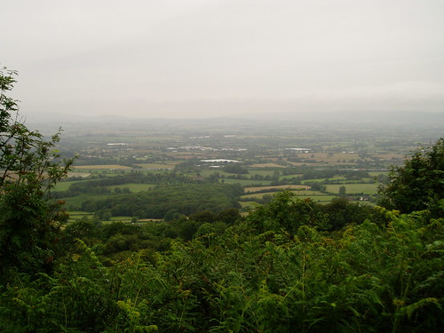
Nice views though, give or take the low cloud.
Wednesday, 4 July 2007
Coastal Mapping Improvement Programme
Reading about this tonight. I presume it's UK mainland only - or at least for the moment? It'll be interesting to see how Seazone get on. I don't envy them! From personal previous experience of ICZMap initiatives it's easier said than done. A 3D surface model of the UK continental shelf incorporating topo and bathy in one model, with one horizontal datum and one vertical datum (ah - the tricky bit!) will be fab.
Subscribe to:
Posts (Atom)