Friday 21 August 2015

1824 - The Loch Foyle Baseline

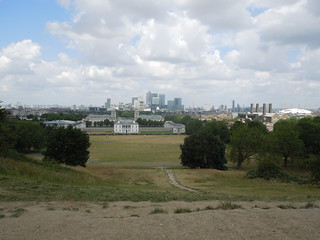
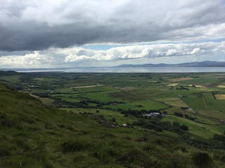
Whilst in Northern Ireland last week my family and I were taken up to Gotmore, a wonderful viewpoint overlooking Loch Foyle and the area of Binevenagh.

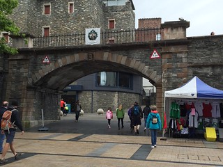
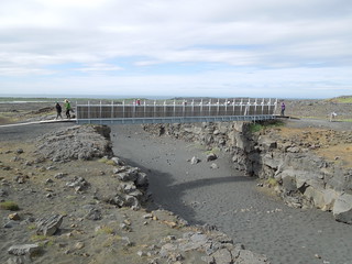
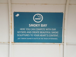
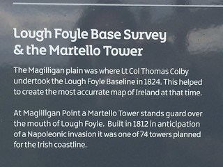
As usual I spotted what looked like a trig and wandered off to find it.  Sadly, it was only an AA direction finder but on the way down I found this enticing sign.
15 08 16 Magilliagan Plain (10)
I bounced back to the family.  "Hey, there's a baseline down there," I wittered pointing at the Magilligan plain in front of us.
15 08 16 Magilliagan Plain (13)
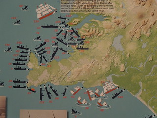
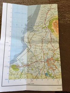
I got the OSNI map out and the penny dropped.  I had seen these trigs when I was reading the map the night before and had wondered why they'd put them on the plain.
15 08 16 Magilliagan Plain (18)
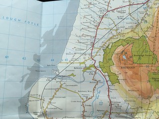
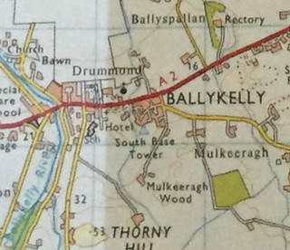
In fact, now I paid more attention to the labelling of the trig triangles,  I realised I was looking at the North Base Tower (at the very top of the image) and the Minearny Base (centre of image).

I had to go and find them.  Roger, my husband, was game (he's put up with this sort of thing for years) but the girls were less supportive, rolled their eyes and hopped into their uncle's car for a lift home whilst Rog and I hunted.

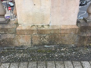
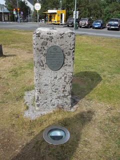
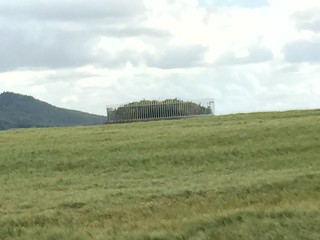
I had no idea what we were looking for.  OK, a trig shaped object would have been my first choice but I didn't expect to find something with a fence around.  This is the North Tower.
15 08 16 Magilliagan Plain (15)
15 08 16 Magilliagan Plain (16)
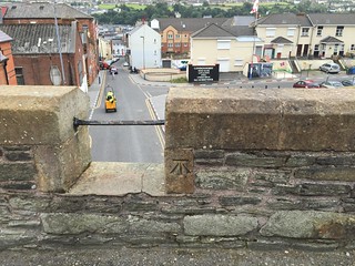
We were unable to get close due to crops in the field, so headed to what I thought was the other end of the baseline, Minearny.
15 08 16 Magilliagan Plain (7)
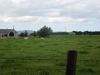
Again, this was on private land so we could only view from a distance.
15 08 16 Magilliagan Plain (6)
Once home I read up on the baseline.  It was, at nearly 8 miles, the longest in its day.  If you read the Trig Ireland webpage you'll see that it wasn't truly necessary, as the Ordnance Survey of Ireland could have just extended the network from the OS GB stations across the water.  However, Lt Col Colby being a thorough surveyor (there are lots of us around) opted for the belt and braces approach.  It took two years to measure the baseline.

When it was resurveyed in 1960 it was found to be out by about an inch.   I make that an accuracy of 2ppm (parts per million) which shows the expertise of the survey team.  Amazing.

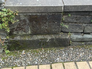
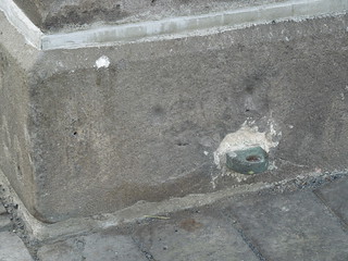
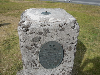
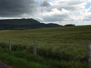
If I had any brains about me I would have realised that I'd been to see the North and Minearny Towers.  It didn't occur to me until I saw the diagram on the webpage that there would be a South tower.  Golly. I really am thick at times.  Here it is in Ballykelly.
2015-08-16 17.24.48
Screen Shot 2015-08-21 at 23.16.34
And even more annoyingly, the pictures on the web indicate it's a piece of cake to visit. OK, so I'd only be able to see the top of the concrete covering the cross hairs defining the actual point, but it would have been fun.  One to see when I'm back there and zero points for common sense from this Chartered Surveyor for not considering the North would have a South.

Saturday 15 August 2015

The Walls of Derry - the Benchmark Circuit

I visited Derry today and walked the wonderfully intact walls.
2015-08-15 13.18.44 HDR
As ever, my focus was on that bit of the wall 10cm above the ground and I was soon rewarded.  I haven't seen an OSNI benchmark for a while.
2015-08-15 13.23.08
I kept my eyes peeled for more.
2015-08-15 13.25.32
And there was another one.
2015-08-15 13.26.48
And more.
2015-08-15 13.32.49
This part of the wall faces towards a Loyalist area (read the sign).
2015-08-15 13.38.03
Every so often you find a hairy one.  [I'm referring to benchmarks here].
2015-08-15 13.40.30 HDR
By this stage my sister-in-law noted that I'd even got her looking for these random cuts in walls.  I am a benchmarking missionary.
2015-08-15 13.47.29
I found seven in all.
2015-08-15 14.01.37
I bet there are more.  There's a part of me that wants to rewalk the walls and see if I've missed one.
2015-08-15 14.24.20

Geo Reykjavik - Small but Perfectly Formed

I didn't find many geo trophies in Reykjavik.  I tried my luck with the Parliament Building thinking there may be a benchmark or some measurement paraphernalia.
DSCN8940
But I didn't find much: just a little benchmark to keep me keen.
DSCN8939
I knew I'd have more luck at Hallgrimskirkja Church.
DSCN8510
This is the only trig pillar I could source on the internet.  It's Danish but has no date on it. Presumably it dates to pre independence (so pre 1944).
DSCN8943
DSCN8944
The metal dial twizzled.  Hours of fun for geodesists.
DSCN8945

Thursday 13 August 2015

America and Eurasia - We Never Were Going to Get Close

Whilst in Iceland last week we twice visited the divergence zone of the North American and Eurasia continental plates.  They are zooming apart at up to 25mm per annum.
DSCN8757
We visited the wonderful spot, Þhingvellir where there are amazing cascades of water from America to Eurasia - over a 40m drop.  This is the best spot on land to see the spreading mid Atlantic ridge.

Below you can see, on the right, the high and mighty N American plate, and to the left, the humble - yeh, right - Eurasian one. My girls were standing on new shiny 9000 year old ground (and slightly newer board walk) here.
DSCN8753
A few days later we visited another site of this divergence zone: a good map is at the USGS site.  We were in the far south west of Iceland at Reykjanesbær and visited the bridge at Sandvík.  This bridge was built recently in 2002 as a symbol between America and Europe (here right and left).
DSCN8950
DSCN8949
It was windy in the gap.
DSCN8952
Do you think we'll ever meet and make up?

Thursday 30 July 2015

Reykjavik Maritime Museum

Continuing my world exploration of Maritime Museums, today I had the opportunity to visit the Reykjavik Maritime Museum here in Iceland.  This is the most northerly establishment I've visited.
DSCN8527
It is sited at the Old Harbour which I hardly explored today.
DSCN8526
DSCN8528
However, with groovy seats like this, made from propellor blades,
DSCN8521
and the Icelandic humour...
DSCN8520
...I'm looking forward to seeing more in the next few days.

Maritime Museums have themes related to their sea history.  For example, the Brazilian (Rio de Janeiro) museum focuses much on their war of independence with the Portuguese; Denmark alternates between their run-ins with the Swedes and international maritime trade (think Maersk).  The Dutch one majors on colonisation.  And the British variant wistfully looks at the days when "the sun never set on the Empire" and also is big on naval protection during the World Wars.
DSCN8541
Iceland's theme is fishing.
DSCN8542
They do an awful lot of it.
DSCN8529
Interestingly I read today that this maritime industry only took off when over 80% of their sheep died after a volcanic eruption and they had to look elsewhere for food/livelihood.  However, the Icelandic Fisheries only states that a change in climate meant agriculture was less viable.  Well, I'd say a volcanic eruption could be quite environmentally changing especially if the ash permeates the soil.

After being pretty sated by tales of fishermen and women, I found a familiar display.
DSCN8530
Like many parts of the world, Iceland has its fair share of sea accidents.  I suspect a pretty strong fetch up across the Atlantic isn't going to help neither will the harsh Arctic weather.  This map shows the numbers and types of incidents of ships over 12 tonnes between 1928 and 1937.
DSCN8533
Quite a graphical image don't you think?  Their cartographical rule of pinning the end of the boat to the rock it hit has given quite a realistic view of ships aground.

I came across a pelorus which I don't recall coming across before.
DSCN8536
It was used to measure bearings at sea between prominent shore marks and also astronomical bodies.  It is gimballed: you may be able to see the weight under the disc.
DSCN8537
I checked it still worked ("not sure you should be touching the displays Ruth," muttered my husband).  I live a risky life....

This is a replica of Konrad Gislason's "Konni the Compass" workshop.  He adjusted, repaired and maintained compasses for 6 decades and was renowned in the Icelandic maritime industry.
DSCN8538
I was amused to see this book on the shelf.
DSCN8540
I suspect that's not everyone's idea of bliss.

Now I think about bliss - with my geo-tinted glasses on - at a tad over 64°N I'm at the most northerly point I've ever been.    And, to keep the theme going, I'm actually the nearest I've ever been to a geographical pole.  When I travelled south in 1995 I only just skimmed past 60°S.  Golly.  I'm going to have to sit down (it must be the thin air up here) this is too much excitement for one day.


Sunday 19 July 2015

Zero Longitude - Zero Latitude

In the last couple of weeks I have managed to cross both the Greenwich Meridian and the Equator.  Sadly not at the same time.

I've straddled the Greenwich Meridian many times, most recently on 27 June in London.
15 06 27 London Greenwich and Pride (5)
I do so love this London view.
15 06 27 London Greenwich and Pride (6)
The last week I was in Uganda and was very much hoping I'd get the opportunity to visit the Equator, having only ever flown over it before which I consider "not doing it properly".  I suppose it's like saying you've visited Mongolia because you flew over it once.  Anyway, I thought my chances were slim when our itinerary took us to an island in Lake Victoria for a few days limiting any opportunity to wander off to bag the Equator for real.

Time was tight for our journey and we had driven straight from our meetings in Kampala.  Never before have I been so inappropriately dressed for a sea journey.
15 07 15 Boat
The sea was pretty choppy (up to Sea State 3) due to strong winds which meant we had to hang on.  My work clothes soaked up the spray quite nicely ;-)
15 07 15 Boat too
As we were travelling my colleague decided to check our latitude.  It was then that we realised we may actually be in the boat long enough to cross the line.

Oooh - we're going to make it!
15 07 15 Boat north of equator
YES - equator crossed. A happy geomatician indeed.
15 07 15 Boat south of equator
Indeed, Bulago Island.  Nearly 02' south of the Equator.
Screen Shot 2015-07-19 at 17.13.29
On our journey back we'd briefed our skipper to stop at the Equator so we could bag it 'properly'.
15 07 16_2 Return to Entebbe (2)
This was as close as we got with the boat's Garmin (lat/long in bottom right hand corner) but I don't think there is need for any further evidence that I've crossed the equator twice.
15 07 16_2 Return to Entebbe (4)
The sea was a lot calmer (Sea State 1) so far easier to get the Ruth-on-equator photo shoot.
15 07 16 Boat back
The problem with these trips is that each time I cross something off my geo to-do list the next challenge appears on the horizon.  So guess what I now fancy doing?  Yup - visiting where the Equator and the Greenwich (or rather, Prime) Meridian cross.  Think I'll need a bigger boat for that.
Screen Shot 2015-07-19 at 17.21.39