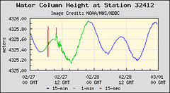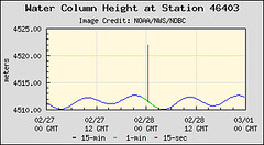
Further north, just over 17 hours later, another buoy measured the effects of the earthquake.

These two places are approx 6000km apart which means that the waves moved at around 350km an hour. You don't get much warning when one of these takes off do you?
The NOAA Pacific Tsunami Warning system was in full swing. At 0645 the first messages started coming through
AN EARTHQUAKE HAS OCCURRED WITH THESE PRELIMINARY PARAMETERS
ORIGIN TIME - 0634Z 27 FEB 2010
COORDINATES - 36.1 SOUTH 72.6 WEST
DEPTH - 55 KM
LOCATION - NEAR COAST OF CENTRAL CHILE
MAGNITUDE - 8.5
EVALUATION
IT IS NOT KNOWN THAT A TSUNAMI WAS GENERATED. THIS WARNING IS
BASED ONLY ON THE EARTHQUAKE EVALUATION. AN EARTHQUAKE OF THIS
SIZE HAS THE POTENTIAL TO GENERATE A DESTRUCTIVE TSUNAMI THAT CAN
STRIKE COASTLINES NEAR THE EPICENTER WITHIN MINUTES AND MORE
DISTANT COASTLINES WITHIN HOURS. AUTHORITIES SHOULD TAKE
APPROPRIATE ACTION IN RESPONSE TO THIS POSSIBILITY. THIS CENTER
WILL MONITOR SEA LEVEL DATA FROM GAUGES NEAR THE EARTHQUAKE TO
DETERMINE IF A TSUNAMI WAS GENERATED AND ESTIMATE THE SEVERITY OF
THE THREAT.
and they escalated from there to
A TSUNAMI WARNING IS IN EFFECT FOR
CHILE / PERU / ECUADOR / COLOMBIA / ANTARCTICA / PANAMA /
COSTA RICA / NICARAGUA / PITCAIRN / HONDURAS / EL SALVADOR /
GUATEMALA / FR. POLYNESIA / MEXICO / COOK ISLANDS / KIRIBATI /
KERMADEC IS / NIUE / NEW ZEALAND / TONGA / AMERICAN SAMOA /
SAMOA / JARVIS IS. / WALLIS-FUTUNA / TOKELAU / FIJI /
AUSTRALIA / HAWAII / PALMYRA IS. / TUVALU / VANUATU /
HOWLAND-BAKER / NEW CALEDONIA / JOHNSTON IS. / SOLOMON IS. /
NAURU / MARSHALL IS. / MIDWAY IS. / KOSRAE / PAPUA NEW GUINEA /
POHNPEI / WAKE IS. / CHUUK / RUSSIA / MARCUS IS. / INDONESIA /
N. MARIANAS / GUAM / YAP / BELAU / JAPAN / PHILIPPINES /
CHINESE TAIPEI
and included evidence from the buoys which were obviousy being closely monitored.
MEASUREMENTS OR REPORTS OF TSUNAMI WAVE ACTIVITY
GAUGE LOCATION LAT LON TIME AMPL PER
------------------- ----- ------ ----- --------------- -----
IQUIQUE CL 20.2S 70.1W 0906Z 0.27M / 0.9FT 72MIN
ANTOFAGASTA CL 23.2S 70.4W 0941Z 0.49M / 1.6FT 52MIN
ARICA CL 18.5S 70.3W 1007Z 0.94M / 3.1FT 44MIN
DART LIMA 32412 18.0S 86.4W 0941Z 0.24M / 0.8FT 36MIN
CALDERA CL 27.1S 70.8W 0843Z 0.45M / 1.5FT 20MIN
TALCAHUANO CL 36.7S 73.4W 0653Z 2.34M / 7.7FT 88MIN
COQUIMBO CL 30.0S 71.3W 0852Z 1.32M / 4.3FT 30MIN
CORRAL CL 39.9S 73.4W 0739Z 0.90M / 2.9FT 16MIN
SAN FELIX CL 26.3S 80.1W 0815Z 0.53M / 1.7FT 08MIN
VALPARAISO CL 33.0S 71.6W 0708Z 1.29M / 4.2FT 20MIN
The sad reality is that the earth moves. However with these monitoring networks you at least know they kick in very quickly and give everyone as much notice as possible to be on alert. That's the best you can ask for at times.
No comments:
Post a Comment