When in Cologne recently I continued my search of all things geo. After my Amsterdam travels I knew what a benchmark should look like and, lo and behold, I soon found one. For sure, most of them were not so elaborately marked, but there are oodles of them.

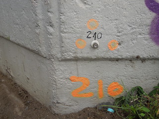
I also learnt a new word - Mess Punkt - a measuring point. You can just about see the word 'Mess' on the plastic surrounding the small brass stud in the photo. They also exist as small metal disks on the pavements. Bizarrely I appear to have forgotten to photograph one.
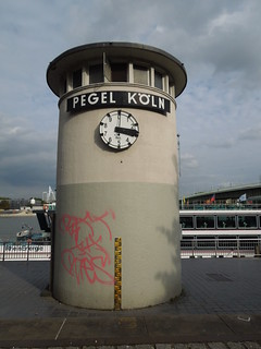
Of great excitement was the tidal tower by the River Rhine. This initially looks to be a time piece, but the dial only goes up to 10. Each tick represents a decimetre. It is showing 3.3m here but the other side showed 3.0 a few minutes earlier and I can't imagine it goes up and down that quickly!

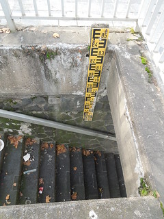
The average depth of the Rhine at Cologne is 3m. Which, at it turned out, was what it was last Thursday. This pole shows depths from 6.9m to 8.5m.

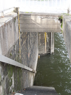
Looking further down the steps there are two more poles. One from 6.9 to 3.2m, and, just peeping out of the water, is the 0 to 3.2m pole. Tidal level 3.0m.

Low water levels obviously restrict the navigable channel, and docking opportunities for vessels with deep drafts. At 2.5m depth it gives a 150m wide navigable channel (more info here). However I suspect the more significant problem is the bridge clearances. A 2.5m depth gives 9.1m clearance so some of the larger cruise ships appeared to have little spare.
Bearing in mind the Rhine here flooded to over 10m less than 10 years ago (which is 10cm short of the top of the yellow pole on the tide tower) you can see why the Cologne authorities have spent so much on flood protection.

I also learnt a new word - Mess Punkt - a measuring point. You can just about see the word 'Mess' on the plastic surrounding the small brass stud in the photo. They also exist as small metal disks on the pavements. Bizarrely I appear to have forgotten to photograph one.
Of great excitement was the tidal tower by the River Rhine. This initially looks to be a time piece, but the dial only goes up to 10. Each tick represents a decimetre. It is showing 3.3m here but the other side showed 3.0 a few minutes earlier and I can't imagine it goes up and down that quickly!

The average depth of the Rhine at Cologne is 3m. Which, at it turned out, was what it was last Thursday. This pole shows depths from 6.9m to 8.5m.

Looking further down the steps there are two more poles. One from 6.9 to 3.2m, and, just peeping out of the water, is the 0 to 3.2m pole. Tidal level 3.0m.

Low water levels obviously restrict the navigable channel, and docking opportunities for vessels with deep drafts. At 2.5m depth it gives a 150m wide navigable channel (more info here). However I suspect the more significant problem is the bridge clearances. A 2.5m depth gives 9.1m clearance so some of the larger cruise ships appeared to have little spare.
Bearing in mind the Rhine here flooded to over 10m less than 10 years ago (which is 10cm short of the top of the yellow pole on the tide tower) you can see why the Cologne authorities have spent so much on flood protection.
No comments:
Post a Comment