A light-hearted blog about all things geomatic as seen through the filter of Ruth Adams, a chartered surveyor. It won't be comprehensive, it'll be hydro biased but, hey, it may make you smile ;-)
Wednesday, 31 October 2007
Newcastle - Must be Time to Sit in the Airport
In between this met up with a PhD student we are sponsoring and chatted to various staff about research opportunities. Decided that I fancy visiting South Tyneside College to use their simulator but I'm sure it'll never happen.
It always lovely returning to my old haunt of Newcastle. Just as well as I usually spend extra hours at the airport biding time waiting for my delayed flight (they even cancelled one once). So sat with the Chair of the Geomatics Faculty and tried to put the geo community world to right. I'm sure we didn't!
Monday, 29 October 2007
Seadatanet
It looks to be aligned with the broader INSPIRE initiative. INSPIRE exists to allow the creation of a European spatial information infrastructure. Spatial information in Europe is currently fragmented with gaps in availability, lack of harmonisation between datasets at different geographical scales and duplication of information collection.
Off to Newcastle tomorrow for a Geomatics Exec meeting. Looking forward to Mike Cooper's lecture on the history of land surveying. I wonder if he'll slip any hydro in?
Saturday, 27 October 2007
Data Quality Survey
Thursday, 18 October 2007
Raising the Ratio the Exeter Way
They had a superb speaker, Sandi Rhys Jones. She has a strong presence and is a successful, measured woman. She has been working in the building profession for over 30 years. She's the type of woman I would love to spend hours and hours talking to: the type of female professional I could use as a role model - they are so few and far between in my arena.
This was a joint RICS/Women in Property event. I don't think I've come across WIP before but it's worth a look. It would be great if I could find myself a female mentor.
Tuesday, 16 October 2007
University College London
A few caught my attention due to their marine applications;
- The impact of new GNSS signals on harbour navigation
- Vertical Offshore Reference Frames (VORF) project
- RTK GPS in the marine environment
- Statistical and GIS-based Approach for Morphodynamic Characterisation and Modelling at Large Spatial and Temporal Scales.
However I was also fascinated by the spectrum of research;
- Bear Ethology Around Romania
- Vulnerability of Reinforced Concrete Structural Elements to Internal Explosions
- Design of Civil Infrastructure - How can we make stations, pavements, trains and other infrastructure more easy to use for all the people?
- Designing an Infection-Resistant Hospital
- Modelling Surface Force Effects on Space Vehicles
Fascinating stuff. I met up with lots of old friends including my Prof from Newcastle (Paul Cross) who is as lovely as ever. A great techie evening
Saturday, 13 October 2007
I Even Shower the Geo Way
Monday, 8 October 2007
Inventor Proves Police Camera Wrong
Wednesday, 3 October 2007
Imagery in Africa and a Bit of Bad News
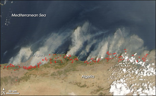
These forest fires in Algeria are clearly seen on MODIS
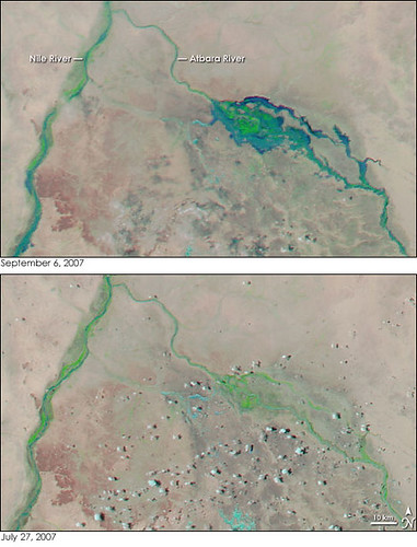
as is flooding in Sudan
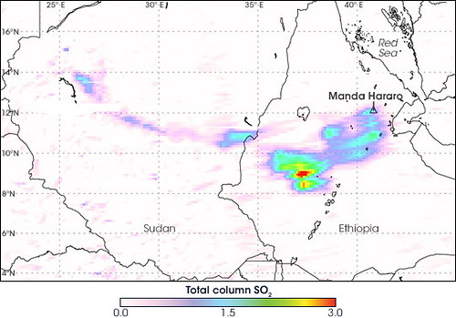
and volcanic activity in Ethiopea.
It is truly amazing what you can do with imagery but I'm sure we're only using a small part of its real potential.
It was sad to read about the closure of the Geoinformatics and Survey course at the University of Zimbabwe due to lecturer shortages. Who can blame anyone for seeking pastures new? If you read on you'll see that the government is now so short of surveyors it is considering allowing undergrads to work. This will surely reduce the incentive to finish a degree if you can be licensed to operate before completing it? But perhaps few in Zimbabwe are currently in a position to be too long-sighted...
Tuesday, 2 October 2007
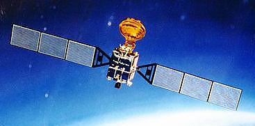
Beidou
What is interesting about it is the fact that unlike 'classical' GNSSs that I was bought up with, this only needs 2 satellites to obtain a fix. Not that this does it by magic. It employs a central ground control station and user terminals with receive and transmit. With only two satellites it is accurate to 100m accuracy but with more satellites the accuracy can be increased to under 20m. Because the ground control station sends and receives data from each receiver the system can only serve up to 150 users simultaneously. The user receivers/transmitters are also bulkier than a GPS receiver and need more power. More information can be found here. [Although this only mentions 4 satellites and I believe they have launched a spare 5th, but not currently in a geostationary orbit].
Positions are referred to Beijing 1954 which could be deemed as a limiting factor to expansion as the transformation between Beijing and WGS84 Datum is only defined over China. However I'm sure it wouldn't take much effort to output Beidou coordinates in a different reference frame.